
The Zig-Zag streets of Branson testify to the time Branson “disappeared.”
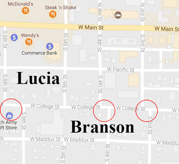
San Francisco’s “Lombard Street,” is famous for being steep and crooked, but has little to do with the early history of San Francisco. On the other hand, Branson’s “College Street,” with its unique “zig-zag” streets, while not as famous, has a lot to do with the early history of Branson.
“Most of the millions who visit Branson each year will never see this unique historic feature. It’s a great way to spend some time between enjoying Branson’s great live shows and attractions and experience Branson history,” said Preston Garrison, Director of Operations for the Branson Tourism Center. “Interestingly, many drive within two blocks of the zig-zag streets on their way to Branson Landing and Historic Downtown Branson,” he added.
As you drive east on Highway 76, Main Street, you will notice a McDonalds to the north (left). McDonalds is at the intersection of Sixth and Main Streets.
Turn right, onto “Sixth Street” and drive south two blocks, passing “Pacific Street” to the apparent end of Sixth Street at its intersection with College Street. It’s only when one “Zigs,” by turning left onto College Street and then, about a quarter of a block down College, “Zags” back onto Sixth Street by turning right, that the “zig-zag” alignment of Sixth Street becomes apparent. If the Sixth street turn is missed basically the same thing can be done by turning onto Fourth or Third Streets.
Some might ask the question, “Why didn’t the people who planned Branson simply have the streets go straight through?” The answer is because the city of Branson, as it was originally incorporated on April 1, 1912, was a combination of two different plats with different roads, alignments, and block lengths.
In about 1882, Ruben S. Branson opened a general store near the mouth of Roark Creek and the White River. He named the post office in his store “Branson,” and even though he moved away, the name stuck, well, kind of.
In the early 1900s, as the railroad started into the “Branson area,” there were competing interests trying to get land and plat towns. The first town platted was “Lucia” on October 2, 1903 with the town of “Branson” platted soon after on October 26, 1903. In general, College Street was the dividing line between the Lucia and Branson town plats, It was the northern edge for Lucia and the southern edge for Branson.
According to most historical accounts, Charles Fulbright and his “Branson Town Company” acquired both town sites by the end of 1903. So, although the two plats became “Branson” in 1903 their roads remained as they were, and are to this very day.
Branson “disappeared” for a short time. The official records of the U.S. Post Office indicate that the name of the “Branson” Post Office was changed from “Branson” to “Lucia” in 1902 and changed back to “Branson’ again in 1904.
Branson’s zig-zag streets might not be at the top of the list of things most visitors plan to experience while in Branson. However, they can certainly provide a pleasant five or ten-minute side trip while on the way to or from Historic Downtown Branson or Branson Landing and testify to the time in history when Branson, if only for a short while, “disappeared.”
They provide an excellent lead into the various historic things to see in “Historic Downtown Branson.” These would include, the site where the Mabe family started Branson’s first show, the “Baldknobbers,” the grave of Ruben S. Branson for whom Branson is named, the oldest free standing building in Branson, and, of course, “Dick’s 5 & 10.”